The Chokepoint That Cannot Be Bypassed
The Strait of Hormuz, the three pipelines built to avoid it, and the OGIM data that explain why they only partly succeed
Published on Linkiesta · 5 May 2026
The Strait of Hormuz is a strip of sea thirty-three nautical miles long and, at its narrowest point, twenty-one miles wide. Roughly twenty-one million barrels of crude oil and condensates pass through it every day, along with about six billion cubic feet of liquefied natural gas: a fifth of world oil demand and nearly a fifth of global LNG trade, according to the U.S. Energy Information Administration. When an Iranian navy commander periodically threatens that it could be closed “in twenty minutes,” the price of Brent reacts within hours. The reason is geographic: every one of those twenty-one million barrels would need to find another way out of the Persian Gulf. And the alternative routes that actually exist — once you strip away the promises — are very few.
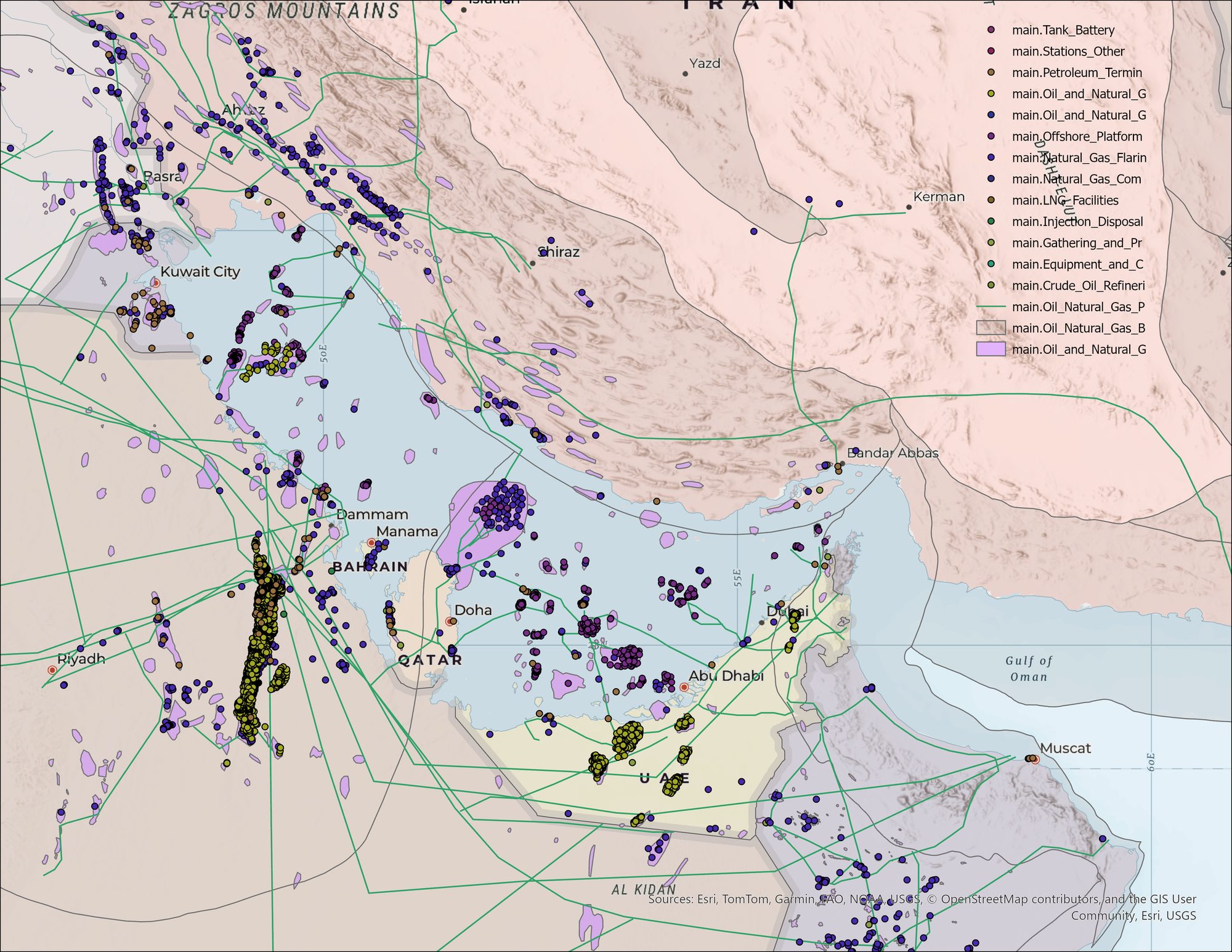
Figure 1 — Oil and gas infrastructure in the Persian Gulf as seen through the OGIM v1.1 database (Rocky Mountain Institute / Climate TRACE): onshore and offshore fields in purple, wells in dark blue, processing and gathering facilities in yellow, the pipeline network in green. The densest concentrations lie along the Ghawar basin (eastern Saudi Arabia), the South Pars / North Field deposits shared by Iran and Qatar, and the onshore cluster in the United Arab Emirates. Produced with ArcGIS Pro on OGIM v1.1, basemap Esri World Hillshade + Charted Territory.
Three pipelines, in three different countries, were built to bypass the strait.
The oldest and largest is Saudi Arabia’s Petroline. Operating since 1981, it is a dual steel line that cuts diagonally across the Najd desert from the country’s eastern coast to its western one: it starts at Abqaiq, where Saudi Aramco processes crude from the Ghawar basin, and ends at Yanbu on the Red Sea, eleven hundred kilometres away. Nominal capacity is five million barrels a day, seven million after the 2019 upgrade. In principle, this single pipe could move all the crude oil France consumes in a year.
The second is the Emirati Habshan-Fujairah line, or ADCOP, built in 2012. It runs three hundred and eighty kilometres from Abu Dhabi to the port of Fujairah, which lies on the other side of the Hajar Mountains and faces directly onto the Sea of Oman. Nominal capacity: 1.5 million barrels a day.
The third is Iran’s Goreh-Jask line, a thousand kilometres inaugurated in July 2021 after decades of delays: it carries crude from Iran’s south-central fields to the terminal at Jask, also on the Sea of Oman. Nominal capacity: one million barrels a day.
| Pipeline | Country | Year | Length | Nominal capacity | Typical throughput |
|---|---|---|---|---|---|
| Petroline (East-West) | Saudi Arabia | 1981 | 1,110 km | 5 → 7 Mb/d | 2-3 Mb/d |
| Habshan-Fujairah (ADCOP) | UAE | 2012 | 380 km | 1.5 Mb/d | 0.6-0.8 Mb/d |
| Goreh-Jask | Iran | 2021 | 1,000 km | 1 Mb/d | 0.25-0.4 Mb/d |
| Kirkuk-Ceyhan | Iraq → Turkey | 1976 | 970 km | 1.6 Mb/d | suspended since 03/2023 |
| Total operational | — | — | ~3,500 km | ~9 Mb/d | ~3-4 Mb/d |
Table 1 — Persian Gulf pipelines built to bypass the Strait of Hormuz. Sources: Saudi Aramco, ADNOC, NIOC, MoP, S&P Global, Reuters.
Add up the nominal capacities and, in principle, nine million barrels a day could leave the Gulf without passing through Hormuz. That sounds like a lot. It isn’t: the gap between nominal and operational capacity is structural in these systems. Petroline typically runs at two to three million barrels because Yanbu is sized for specific crude grades. ADCOP moves roughly six to eight hundred thousand barrels: ADNOC keeps much of its exports flowing through the Gulf’s own terminals, which are more economical. Goreh-Jask runs at two hundred fifty to four hundred thousand: downstream infrastructure is incomplete, and Iran, under sanctions, exports less than a third of its theoretical capacity. Iraq’s Kirkuk-Ceyhan line has been shut since March 2023 following an International Chamber of Commerce arbitration between Baghdad and Ankara. Add up the operational figures and the “real” bypass — the one that could be switched on tomorrow morning — comes to roughly 3-4 Mb/d. Figure 2 puts that asymmetry to scale.
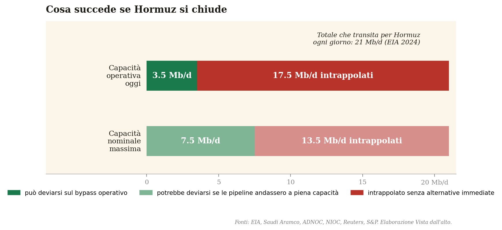
Figure 2 — The balance between the crude oil that transits the Strait of Hormuz every day (21 Mb/d, 2024 EIA figure) and the available bypass capacity, under two scenarios: the system’s current operational capacity (about 3.5 Mb/d) and the theoretical maximum nominal capacity (about 7.5 Mb/d). Even in the best-case scenario, two-thirds of the Gulf’s oil would have no alternative route around the strait.
This asymmetry also shows up in the data. OGIM, the open database maintained by the Rocky Mountain Institute and Climate TRACE, catalogues roughly five million geolocated oil and gas assets worldwide — wells, refineries, terminals, platforms, pipelines — drawn from national agencies, operators, and satellite detection systems such as NOAA’s VIIRS Nightfire. Filter it down to the Persian Gulf, and the picture is stark.
| Category | Inside the Gulf | Outside (bypass) | % trapped |
|---|---|---|---|
| Refineries | 19 | 5 | 79% |
| LNG facilities | 23 | 4 | 85% |
| Oil terminals | 101 | 4 | 96% |
| Offshore platforms | 364 | 0 | 100% |
Table 2 — Persian Gulf oil and gas assets classified by dependence on the Strait of Hormuz. Data: OGIM v1.1 (Rocky Mountain Institute / Climate TRACE), analysis by Vista dall’alto.
The most striking figure is the one for gas. All seventeen liquefaction trains at Ras Laffan in Qatar — the largest LNG complex on the planet, which alone exports just under twenty per cent of the world’s LNG — sit inside Hormuz. Without exception. Even the gas extracted from the shared South Pars and North Field deposits, which feeds half of the global LNG market, has to pass through the strait.
The historical reasons why the geography of the bypass never expanded are well known. Qatar spent years exploring the idea of a transcontinental pipeline to the Red Sea or the Mediterranean via Syria and Turkey, but the 2017 Gulf crisis froze any infrastructure cooperation among GCC states for years. The 2021 al-Ula reconciliation reopened diplomatic channels, but it has not yet translated into construction. Saudi Arabia is planning a new, 2,740-kilometre “Persian Gulf Bypass” pipeline (OGIM lists it as being in the permitting stage), but with no official date for entering service.
The Gulf’s energy architecture, built piece by piece over the half-century that followed the nationalisation of the oilfields, is structurally unbalanced. It reflects an era — the 1960s and 1970s — when Hormuz was not seen as a systemic risk, and when any investor preferred to settle in the calm waters inside the Gulf rather than expose itself to the Sea of Oman. That long-term bet leaves the world economy today with an enormous exposure to a single chokepoint: if Hormuz closes, four-fifths of the Gulf’s oil stops moving. And the satellites, which keep watching the queues of tankers outside Ras Tanura, Kharg and Mina Al Ahmadi every single day, see it happen in real time.