Gaza, six months on: what the satellite sees and reconstruction doesn't tell
The Board of Peace awards its first contract, a military base, while satellite imagery shows new outposts, an earthen berm over twenty kilometers long, and a corridor cut through the built-up area. A comparison between published open-source sources and an original PlanetScope analysis.
Published on Linkiesta · 12 August 2026
On August 7 the Board of Peace awarded its first contract: a military base, not a hospital, not housing for the displaced. It is the body established at Donald Trump’s initiative to oversee the reconstruction of Gaza, which he himself chairs and whose day-to-day management he has entrusted to his son-in-law Jared Kushner and to Steve Witkoff. The base measures one hundred by one hundred twenty meters and is designed for one hundred fifty soldiers of the international stabilization force. It is being built by Arkel International, a Louisiana company that has already worked for the American military in Iraq. According to a report first published by the Guardian, the contract has not yet been formally finalized, but is in its final stages.
The starting point here is methodological: the satellite has no opinions, it measures. From October to today the political context has changed. There is a ceasefire, there is a fifteen-point plan, there is an international body with a name that promises peace. The physical trajectory on the ground, judging from the data that follows, has not changed. The analysis below does not simply cite satellite sources published by others: for this article, two PlanetScope images were downloaded, dated January 8 and March 3, 2026, of the same location in the Strip. The comparison is the clearest summary of these six months.
The Yellow Line, explained
With the October 2025 ceasefire, a demarcation line was drawn, informally called the “Yellow Line,” marking the point to which Israeli forces withdrew from their positions of maximum advance. It was meant to be a temporary line, the first step of a gradual withdrawal. Since then that line has not moved back: according to satellite analyses compiled by Al Jazeera, Forensic Architecture and BBC Verify, it has instead consolidated into a physical, permanent border that today delimits a band covering between 55 and 60 percent of the territory of the Strip under direct Israeli control. At the end of May, Netanyahu signaled his intention to extend military control to 70 percent of the territory.
Wikipedia has given it its own entry, “Yellow Line (Gaza).” It is a sign of how much the line has become a permanent news subject, no longer a technical detail of a ceasefire.
What the open-source sources document
Three independent organizations, with a stated methodology and dated imagery, have tracked the evolution of the Yellow Line month by month.
Al Jazeera’s Open Source Unit published an analysis on June 3 that, based on satellite data through May 2026, identifies 40 distinct Israeli military outposts within the boundaries of Gaza. The most significant figure is not the total, but the breakdown: eight of these bases were built entirely after the October 2025 ceasefire took effect, and one was still under active construction at the time of publication. Among the documented sites: a base built on the ruins of a cemetery in Khan Younis, with work starting in November 2025 and “fully equipped” with vehicle staging areas by May; a fully fenced structure in Beit Lahiya; a 70 percent expansion of the footprint of a site east of Gaza City between October 2025 and May 2026. On July 23, Al Jazeera returned to the subject with an analysis devoted to an earthen berm with a trench running over 23 kilometers (the Strip measures about 40 kilometers along its entire length), built in the preceding months and documented by a Planet Labs image from July 1, also distributed via the Associated Press. In some places the berm crosses beyond the agreed Yellow Line: by about 400 meters in Khan Younis, and by up to 1,300 meters in Rafah.
Forensic Architecture, the spatial research center at Goldsmiths, University of London, which for years has applied to the reconstruction of conflict events the same logic of physical evidence used in Sentinel-based analyses, maintains on its “Frames” platform an ongoing monitoring effort on the Yellow Line: not a single piece, but an archive of dated, georeferenced verifications. Their measurements, updated as of late May, report a combined 25 kilometers of new berms, with a single continuous stretch of 11 kilometers running from Wadi Gaza to Khan Younis, the longest stretch documented so far. They had already tracked, since December 2025, the construction of a base in Jabalia, in the northern part of the Strip, progressively fortified in the following months.
BBC Verify, the BBC’s satellite verification team, published a piece on July 29 co-authored by correspondent Yolande Knell along with Emma Pengelly and Benedict Garman, in which the satellite imagery analyzed shows, in the BBC’s own summary, that “in some areas the earthen berm effectively shifts the border” further into the Strip than the nominal Yellow Line. In July alone, according to the article, dozens more buildings were demolished beyond the Yellow Line in the area of Khan Younis and Deir al-Balah. Andreas Krieg, of King’s College London, commented on the shifting of the yellow concrete blocks that physically mark the border, describing it, in statements reported by the press, as a tool of territorial pressure. Reuters, on July 28, reported the same dynamic from the perspective of residents of the Zeitoun neighborhood in Gaza City, who find the yellow blocks moved overnight.
A clarification is worth making here, since the theme of the “moving border” and “yellow line” also recurs elsewhere: Bellingcat published a rigorous satellite analysis in May of a “Yellow Line,” but it concerns southern Lebanon, a distinct Israeli security zone that has damaged or destroyed at least 46 Lebanese towns and villages. It is the same Israeli military terminology applied to two different theaters, not the same border. Anyone writing on this subject should keep the two carefully separate: for that reason it is not cited here as a source on Gaza, but noted as a methodological aside.
The map below (fig. 1) summarizes in simplified form the points cited above: the course of the Yellow Line and the approximate positions of the sites documented by Al Jazeera, Forensic Architecture and BBC Verify.
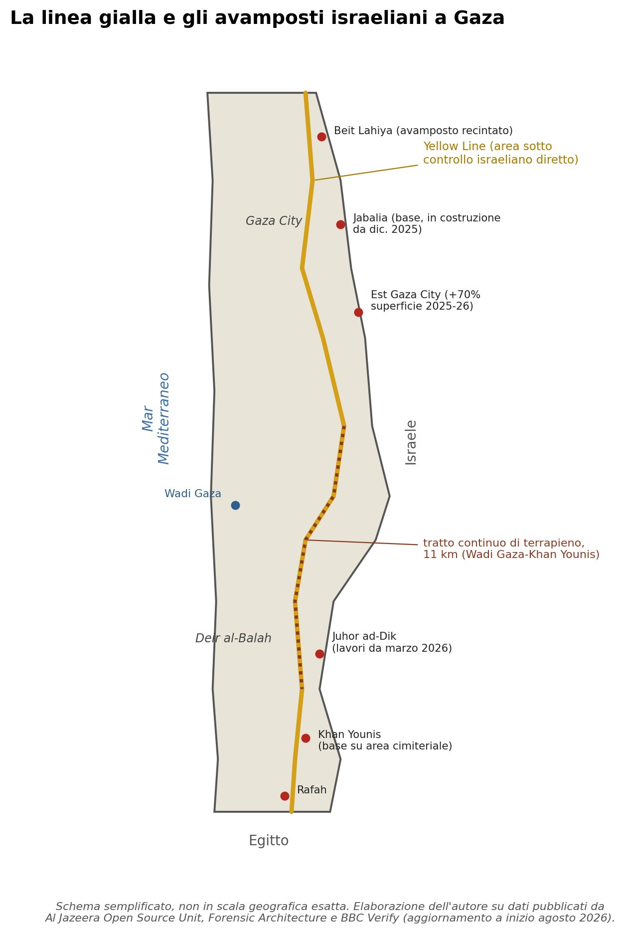
Figure 1 — Simplified diagram, not to exact geographic scale, of the Yellow Line and the main outposts and berms documented by the open-source sources cited in the text. Compiled by the author from Al Jazeera Open Source Unit, Forensic Architecture, and BBC Verify data.
What the new images show
All the sources cited above use the same satellite tools employed for the analysis in this article, Planet Labs and in some cases Sentinel Hub, but they remain secondhand sources until the data is verified directly. The two PlanetScope acquisitions used here, dated January 8 and March 3, 2026 (the most recent available at the time of writing), do not cover the entire Strip but a limited area where the sources cited above reported new activity.
The comparison (fig. 2) is stark. On January 8, on the eastern side of the observed area, there is a small square outpost, fenced, isolated on a bare mound of earth: a modest structure with a single visible access point. On March 3, at the same spot, that structure has become a circular fort. An oval berm about a hundred meters in diameter encloses a fortified central structure, and a network of vehicle tracks radiates outward. In less than two months, an outpost became a permanent fortified position.
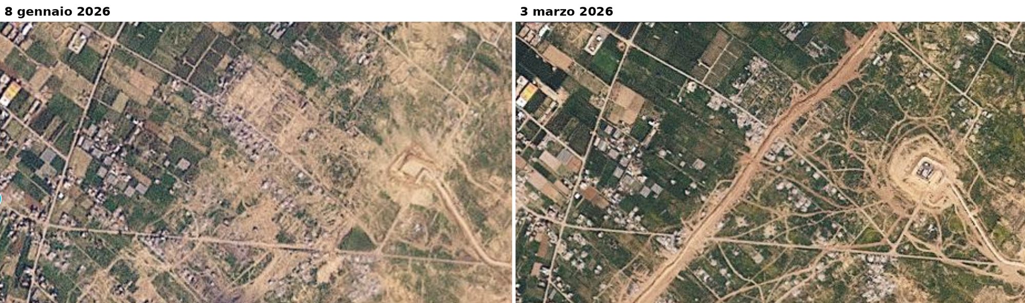
Figure 2 — Same location, two dates. On January 8, 2026 (left) there is a small square outpost on a bare mound of earth. By March 3 (right) it has become a circular fort with a perimeter berm and access tracks radiating outward. Source: PlanetScope / Piero Boccardo.
The most interesting finding is not the growth of the fort itself: that is already documented, in other areas, by the sources cited above. More useful is to look at a second location, a short distance from the first (fig. 3). In the January 8 image the area is continuous urban and agricultural fabric, crossed only by a pre-existing diagonal road. In the March 3 image, at the same spot, a corridor of cleared earth runs alongside that road, with sharp, straight edges incompatible with a natural channel. A network of vehicle tracks radiates from a central point where, in January, there was nothing. It is a newly cleared strip, with the characteristics of a transit or staging area for vehicles, appearing in the same time window in which the fort described above develops.
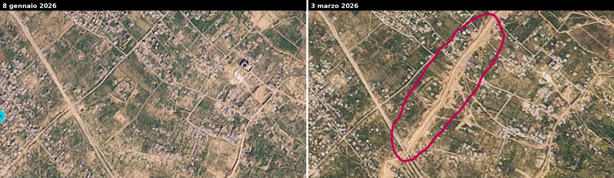
Figure 3 — A second location in the same area, a short distance from the first. On January 8, 2026 (left) the urban and agricultural fabric is continuous, crossed only by a pre-existing road. On March 3 (right, highlighted in red) a corridor of cleared earth runs alongside the road, and a network of vehicle tracks radiates from a central point that was not there before. Source: PlanetScope / Piero Boccardo.
At the scale of the whole Strip, the comparison is less conclusive. An image from February 2023 and one from March 2026, at the resolution needed to cover the entire territory, do not allow a new berm to be reliably distinguished from a road that already existed before the war: a structure only a few meters wide requires narrowing the field of view to be identified. Wide-area images show the context; higher-detail images like the two above show the evidence.
The numbers that don’t add up
Let’s put these pieces together. The Fondazione Leone Moressa and other independent estimates place the cost of rebuilding Gaza between 70 and 75 billion dollars, with nearly 200,000 buildings to be rebuilt according to estimates that have circulated repeatedly in recent months. The Board of Peace, the body meant to administer those funds and that process, opened its activity by awarding a contract for a military base. The disarmament of Hamas, meanwhile, has not even begun: Israel sets it as a condition for its own withdrawal, Hamas sets the Israeli withdrawal as a condition for its own disarmament. Mobile homes for hundreds of thousands of displaced people remain, to this day, outside the Strip.
What does move, with a regularity that official statements lack, are the berms, the yellow concrete blocks, and the tracks connecting an old checkpoint to a new fort, as shown by the PlanetScope comparison above of a single location in the Strip observed over less than two months.
What the satellite cannot say
A methodological caveat is worth making, today as always. A satellite image says that a structure was not there and then is, that a berm has lengthened by several kilometers, that a strip of land has been leveled. It does not say who decided to build it, under what chain of command, nor whether it is part of a permanent annexation plan or a temporary security measure that no one, in practice, still intends to remove. That is a political and legal judgment that belongs to others: analysts such as Andreas Krieg are already speaking openly on this. The satellite measures. The rest, the reconstruction of meaning, remains human work, and it must be done with data in hand, not with announcements.
Piero Boccardo is a full professor of Geomatics at the Politecnico di Torino and founder of “Vista dall’alto,” an investigative satellite-imagery analysis platform covering the environment, territory, and geopolitics.